Source: Prime Minister’s Press Secretariat, Solomon Islands
The Pacific Oceanscape, endorsed by Pacific Island Forum Leaders in 2009, is a political commitment to protect, manage and sustain the cultural and natural integrity of the ocean for present and future generations.
The first priority identified for immediate implementation under its framework was establishing jurisdictional rights and responsibilities. However, to date, only seven out of 14 Pacific Island countries have accurately mapped and legally declared the outer limits of their maritime zones in national maritime legislation, and one third has successfully negotiated and concluded maritime treaties on shared and overlapping claims.
In the Pacific region, there are approximately 49 shared and overlapping Exclusive Economic Zones (EEZs). As early as the 1990s, Pacific Island countries began working with the Pacific Islands Forum Fisheries Agency (FFA) to establish territorial baselines as a basis for measuring the indicative outer limits of their 200 nautical mile EEZs. Establishing these indicative limits meant that licence fees could be allocated and distributed to countries under the United States Treaty on Fisheries between the Governments of Certain Pacific Island States and the Government of the United States of America (referred to as the ‘US Tuna Treaty’). However, these limits were still provisional and were not officially recognised.
According to the 1982 United Nations Convention on the Law of the Sea (UNCLOS):
‘Article 75 Charts and lists of geographical coordinates
- Subject to this Part, the outer limit lines of the exclusive economic zone and the lines of delimitation drawn in accordance with article 74 shall be shown on charts of a scale or scales adequate for ascertaining their position. Where appropriate, lists of geographical coordinates of points, specifying the geodetic datum, may be substituted for such outer limit lines or lines of delimitation.
- The coastal State shall give due publicity to such charts or lists of geographical coordinates and shall deposit a copy of each such chart or list with the Secretary-General of the United Nations.’
Therefore, it is very clear that countries need to officially declare the outer limits of their maritime zones as it removes the considerable uncertainty over maritime borders between neighbouring countries. It can even pose a potential threat to maritime peace and security in the region. In October 2013, the Nauru District Court fined a Spanish fishing vessel and its crew around USD 1 million for illegally fishing in Nauru’s EEZ. The vessel’s captain claimed they were fishing in Kiribati’s EEZ and not Nauru’s. There have been many reports of similar incidents elsewhere. Legal enactment of the extent of a country’s EEZ removes uncertainty about the ocean area under its jurisdiction.
In my experience in working in the Pacific region, I have seen how important this process is. It empowers Pacific Island countries to control activities that use or impact their marine resources and contributes to improving global and regional ocean governance. In particular, maritime boundaries are vital for monitoring, control and surveillance, not least the control of illegal, unreported, and unregulated (IUU) fishing. It is critical to establish maritime boundaries before countries undertake any exploration or exploitation of deep sea minerals in the area under their national jurisdiction. Delimitation of maritime zones has a role in addressing the impacts of climate change and sea-level rise in that it safeguards the sovereign rights of Pacific Island countries.
As I already noted, the establishment of maritime boundaries is a regional priority under the Framework for Pacific Oceanscape, but progress requires stronger awareness coupled with political will on the part of leaders.
From early 2000, my role as the Pacific Islands Regional Maritime Boundaries Technical Officer within SPC’s Geoscience Division, in cooperation with partners including Geoscience Australia, Australia’s Attorney General’s Department, the Commonwealth Secretariat, FFA and GRID Arendal, has been heavily involved in assisting Pacific Community members to develop and define maritime zones and shared boundary solutions.
A major part of my responsibilities is also providing technical and legal assistance to member countries to declare their baselines and maritime zones - including their sovereign outer boundaries - in domestic legislation, and to deposit this information with the UN as part of meeting their obligations as parties to UNCLOS.
From my perspective, the consortium of partners has been widely recognised as a driving force in providing technical and legal assistance to Pacific Island countries’ own national maritime boundary teams. From 2012 to 2016, 14 new maritime boundary agreements were signed by the Leaders of 11 Pacific Island countries. During the Pacific Island Forum Leaders’ meeting held in Cook Islands in 2012, a side event was organised to mark the signing of seven bilateral maritime boundary agreements and one trilateral agreement. This was the first time that the conclusion of maritime boundary negotiations had been celebrated.
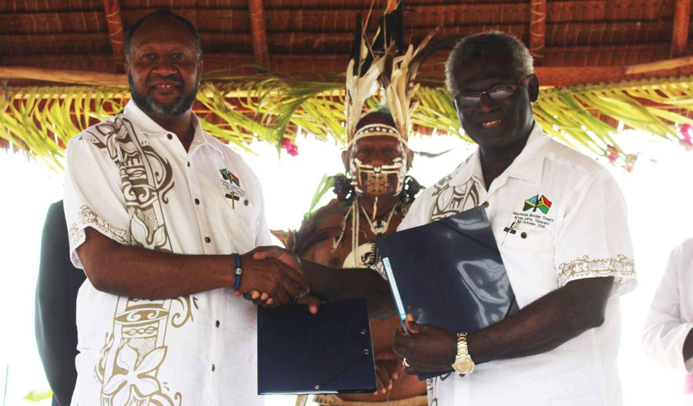
Since then, at least one maritime boundary agreement has been signed every year in our region. On 7 October 2016, Prime Minister Manasseh Sogavare of Solomon Islands and his counterpart from Vanuatu, the Hon Charlot Salawai, acknowledged the successful conclusion of 33 years of maritime boundary negotiations between their countries at a special signing ceremony. I am delighted by this landmark event, but we have more to do. SPC’s work continues as part of the Pacific Islands Regional Maritime Boundaries Project.