
 The Republic of the Marshall Islands has reached a major milestone in ocean resource management and international relations following the submission of their completed maritime boundary legislation to the United Nations on 22 April 2016.
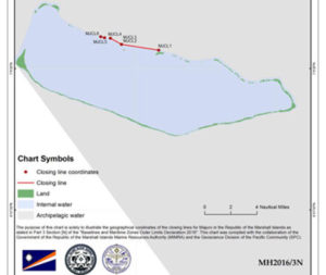
This legislation includes more than 450 pages of geographical coordinates, treaty agreements, and a total of 25 charts which will officially declare the baselines and the outer limits of all of its maritime zones under the national jurisdiction of the Marshall Islands.
“This is a real achievement for the Government of the Marshall Islands and for the Pacific Community (SPC),” the Geoscience Division Director at the Pacific Community (SPC), Professor Michael Petterson, said. “It represents the successful conclusion of three years of sustained effort from the Marshallese technical and legal teams, in close collaboration with the SPC Regional Maritime Boundaries Unit and the Government of Australia.”
The new legislation will officially declare the archipelagic baselines around the “Ralik” and “Ratak” island chains and removes the uncertainty regarding the area of ocean space under the jurisdiction of the Marshall Islands. Formalising these boundaries is a critical step toward improved governance, conservation and management of ocean resources, including fisheries.
Much of the necessary groundwork for this achievement was laid last year, when SPC and the Australian Government coordinated a North Pacific workshop focused on building the capacity of geospatial experts and legal officers from Palau, the Marshall Islands, and the Federated States of Micronesia.
During this workshop, the team from Marshall Islands drew the baselines and drafted the new maritime zones legislation which was passed by the Marshall Islands Parliament (the Nitijela) in March this year.
Benedict Yamamura of the Marshall Islands Marine Resources Authority was part of the team that developed and recently submitted this legislation at the United Nations Headquarters in New York.
Acknowledging the support and assistance provided by SPC and the Australian Government, Yamamura also said, “this is truly a work we can call our own.”
SPC’s Regional Maritime Boundaries Unit provides assistance to the Government of Marshall Islands in partnership with the Australian Government, the Pacific Islands Forum Fisheries Agency, GRID-Arendal, the University of Sydney, the Commonwealth Secretariat and a non-profit organisation, called the Independent Diplomat, which is based in New York, USA.
Media contact:
Molly Powers-Tora, Coordinator, Ocean and Tides Knowledge Unit, [email protected] or +679 3249250